Eureka Gold Mine


Gold was discovered in Cracker Creek in 1862 and contributed to a huge mining boom that
fueled the settlement of eastern Oregon. Numerous mining camps sprung up along the creek as
well as further downstream on the Powder River and in the adjacent McCully Creek. Eventually,
the miners found the sources of the placer gold high up in the Elkhorn Mountains and more
mining camps were established there to recover the gold. By 1900, more than $9 million of gold
had been recovered from the lode deposits alone.
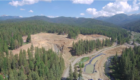
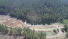
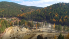
The Eureka Mine is an active placer gold mine located in Baker County, Oregon. The property consists of five private parcels and one federal mining claim encompassing 54.03 acres that are located in the Cracker Creek drainage of the Sumpter Mining District.
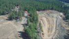
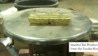
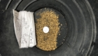
The mine contains excavating and hauling equipment, a processing plant capable of 200 – 400 cubic yards per day, and supporting infrastructure, including tailings and settling ponds, a commercial water well with conveyance pipelines and pumps, and hardline electrical power. It also contains cabins for employee housing. Access to and around the mine is very good.
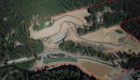
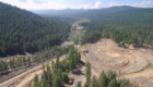
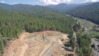
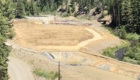
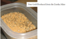
The mine is divided into two parts, a creekside portion and a hillside portion. The creekside portion consists of the active Cracker Creek channel and its associated broad floodplain. This 6.136-acre floodplain was evaluated with geophysical surveys that identified a substantial volume of unmined gravels left by the dredge, including all of the gravels on bedrock and up to 35 feet of gravels on top of bedrock, totaling 237,586 cubic yards. The mineral resource is estimated to be about 89,652 ounces of gold and valued at about $134,478,000 given current market prices of $1,500 per ounce.
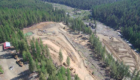
The hillside portion of the property is where the current mine activities are located. Hillside mining began about 25 years ago. It started in two small tributary drainages referred herein as the North Pit and South Pit drainages and progressively developed into specific mining pits. The hillside deposit consists of a sequence of Pleistocene gravels that contain gold throughout the
section; although the most gold is found in the lower sections and is concentrated on bedrock. Geophysical surveys identified a pre-Pleistocene topography that consisted of pale-river valleys and flat-topped benches that were buried by the gravel deposit. The gravels in the paleo-valleys are as much as 160 feet thick and gravels on the surrounding benches are about 30 – 80 feet
thick. The history of mining the hillside deposits was poorly documented until recently and this evaluation pieced together expected ore grades that showed a significant economic mineral potential. It was determined that a defined lower portion of the deposit is estimated to contain 3.12 million cubic yards with about 67,879 ounces of gold valued at $101,816,500 given the
current market prices.
Therefore, this technical evaluation concludes that the combined estimated resource potential for the creekside and hillside portions at the Eureka Mine is 157,531 ounces of gold valued at $236,294,500 given the current market price. This resource estimate does not include the 10-acre federal mining claim as there was not enough data for an accurate evaluation. Feasibility studies or mine plans were not part of this evaluation. Recommendations are given to further expand the economic potential and expand the mine. Nearby properties are recommended for acquisition.
To view the full 182 page report please Contact Us.
Inquire Now!
Office: 866-539-0860
Email: Brandon@swanenergyinc.com